|
|
|

|
|
|
 |
 |
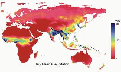
World Water and Climate Atlas
The
IWMI World Water and Climate Atlas gives irrigation and agricultural planners
rapid access to accurate data on climate and moisture availability for
agriculture.
The
Atlas includes monthly and annual summaries for precipitation, temperature,
humidity, hours of sunshine, evaporation estimates, wind speed, total
number of days with and without rainfall, days without frost and Penman-Montieth
reference evapotranspiration rates.
The core of the Atlas
is data assembled from weather stations around the world for the period
1961-1990. Data can be extracted in summary, manipulated using the Atlas
software, or exported in a standardized format for use in other applications.
Users can also include their own local data for a more detailed picture
of a particular area.
Applications include:
- identifying areas
suitable for rainfed agriculture
- determining how
much irrigation is needed in relation to what the climate provides
- providing inputs
for hydrological modeling of river basins
- extracting climate
inputs for crop modeling
For more information
on the Atlas follow the links to the left.
Questions and Queries: Priyantha Jayakody
(Remote Sensing and GIS Expert)
Model and Web related Queries: Sadir Mohiyadeen
(Senior Software Developer)
 |
THIS
PROJECT WAS MADE POSSIBLE BY THE GENEROUS SUPPORT
OF
THE GOVERNMENT OF JAPAN (OFFICIAL DEVELOPMENT ASSISTANCE) AND
THE UNITED STATES AGENCY FOR INTERNATIONAL DEVELOPMENT (USAID) |
|
|
|
|
| |
|
 |
|
|
|
|
This page was last updated on
Friday, February 13, 2009
|
|